Project
The Cainhoy Peninsula – Clements Ferry Road
Overview
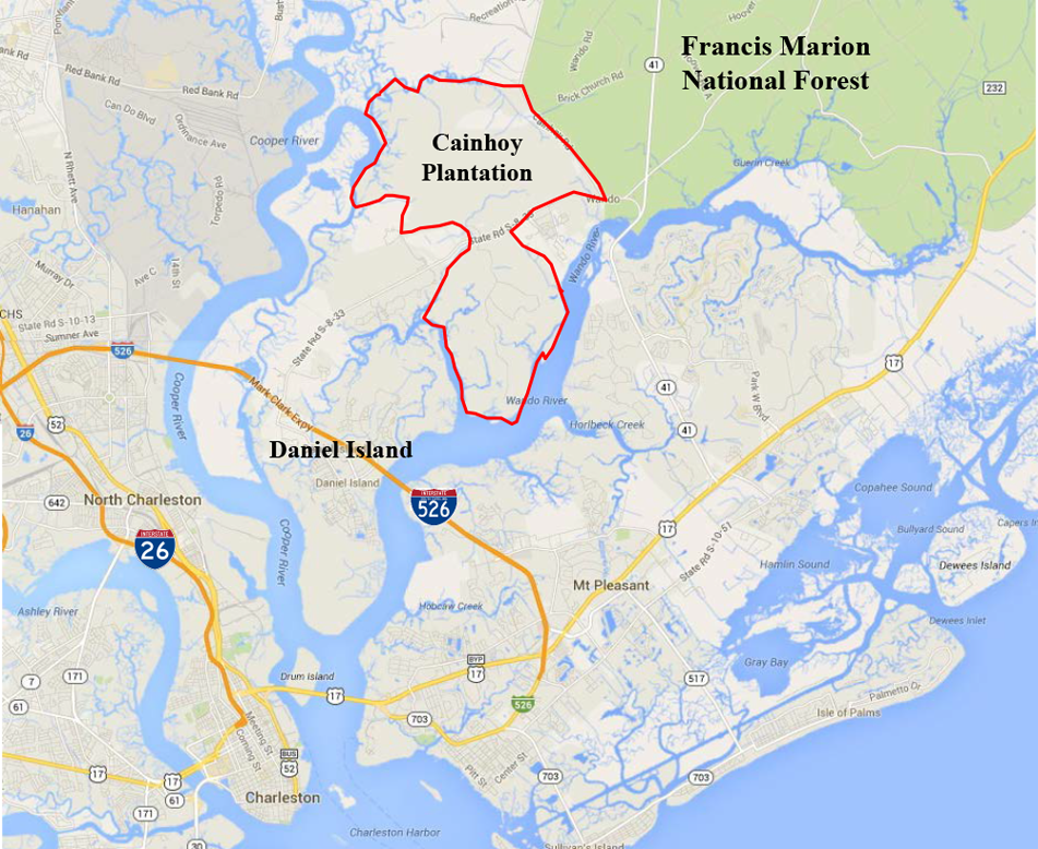
About 20 miles from the historic heart of Charleston lies another significant peninsula—low lying, flood-prone, and steeped in history: Cainhoy.
This 9,000-acre property—twice the land area of the Charleston Peninsula—is one of the largest and most ecologically sensitive undeveloped properties in the Charleston area. The northern portion of the property shares a two-mile border with the Francis Marion National Forest, home to four designated wilderness areas, longleaf pine savannahs, and a number of threatened and endangered species, including the red-cockaded woodpecker and the northern long-eared bat. The southern portion of the property is bordered by the Wando River and Flagg Creek, and crossed by many smaller, unspoiled creeks teeming with life, including species that are significant to local fisheries such as redfish, flounder, blue crabs and oysters.
Sign the Petition Now!

This area was home to Native Americans who lived along the banks of the Cooper and Wando rivers, hunting for food and picking oysters from the marsh. Clements Ferry Road, which bisects the Cainhoy property, was once an important colonial route linking ferries between Charles Town, East Cooper, and Cainhoy. In 1712, over 150 years before the Civil War, the Jack Primus community was established by a free Black man who purchased 100 acres from the Cainhoy Plantation in 1712. Jack Primus and many other historic African-American settlement communities remain in the area today.
Tragically, there is a current proposal to over-develop this ecological treasure.
In 2014, the City of Charleston approved a Planned Unit Development (PUD) that would allow developers to build as many as 18,000 new homes. That is roughly the size of the entire Town of Summerville. The proposed plan would require “taking” (which would include displacement and likely death) dozens of endangered red-cockaded woodpeckers and filling-in nearly 200-acres of wetlands. The PUD also allows for 700 – 900 individual docks. These actions would transform this unspoiled peninsula into an “Anywhere, USA” suburb, irreversibly altering the landscape and locating thousands of new residents in a floodplain, all while simultaneously degrading the rural character and quality of life for residents of Jack Primus, many of whom have lived on their land for generations.
THE BACKGROUND
While we do not endorse any specific number of units being built on this property, we worked with partners to commission multiple alternative plans to show that the developers could achieve their goals in more sustainable ways. Sadly, these alternative plans have been ignored by the developers.
The Conservation League is working with partners, including the Southern Environmental Law Center, Charleston Waterkeeper, and the South Carolina Wildlife Federation to ensure a balanced future for the Cainhoy Peninsula that does not harm endangered species and does not put future residents at risk for future flooding.
THE LATEST
In 2022, the Coastal Conservation League—along with our partners at the Southern Environmental Law Center, Charleston Waterkeeper, and the South Carolina Wildlife Federation—filed a suit in federal court challenging the permits that would allow the “taking” of red-cockaded woodpeckers and filling of nearly 200-acres of wetlands.
In April 2023, we also learned that the development as proposed could have negative impacts on the northern long eared bat, which was recently listed as federally endangered. The species has been documented in the adjacent Francis Marion National Forest, and there is suitable habitat on the Cainhoy property.
In September 2023, we learned that the U.S. Fish & Wildlife Service and U.S. Army Corps of Engineers reopened consultation to study potential impacts to both the northern long-eared bat and the red cockaded woodpecker.
Get immersed in the beauty of Cainhoy through this Bitter Southerner article featuring the peninsula.
We’ve continued our fight in the court system, with the help of the Southern Environmental Law Center, and our co-plaintiffs Charleston Waterkeeper and the South Carolina Wildlife Federation. Now we’re bringing the issue before the City of Charleston – with a call to update the 30+ year old development agreement.
The South Carolina Local Government Development Agreement Act gives local governments a tool to revisit outdated development agreements such as the one for the Cainhoy Development.
Under the Development Agreement Act, local governments can apply new laws and policies to existing development agreements if “substantial changes have occurred in pertinent conditions existing at the time of approval of the development agreement which changes, if not addressed by the local government, would pose a serious threat to the public health, safety, or welfare.” It’s time for it to be revisited and revised. Sign the petition now.
Want to stay updated on Cainhoy? Sign up for our emails.
IN THE NEWS
- Years-old development entitlements complicate Charleston’s flood planning
- First bats, now birds: Feds ramp up inquiry of Point Hope’s harm to endangered species
- Clearcutting forest for 18,000-home Cainhoy development paused due to wildlife concerns
- 18,000-home Cainhoy plan is a ‘total tragedy’ for endangered bird. SC groups are suing
- Environmental groups file lawsuit over proposed Cainhoy Peninsula housing development
- Large Cainhoy development would exacerbate flooding, groups say
- How new development in Cainhoy threatens historic burial grounds
- Clements Ferry Road, from Native American path and Revolutionary route to traffic jams
- Cainhoy Peninsula development could threaten preservation of historical sites
- Balancing history and building in a forest: How development is reshaping Cainhoy peninsula


